Just hours after taking office on January 1, 2026, Mayor Zohran Mamdani signed Executive Order 04 to establish the Land Inventory Fast Track (LIFT) Task Force. The interagency task force, led by Deputy Mayor for Housing and Planning Leila Bozorg, has been charged with identifying underutilized public land that might be used for future housing developments. But even if the LIFT Task Force can identify potential underused lots owned by the City, will it be possible to rezone them for residential use?
 In December 2025, NYC selected Camber Property Group, Services for the UnderServed (S:US), and Essence Development to build “Hudson Mosaic,” an affordable housing and recreation center project that would provide 280 affordable homes and a new community center on a vacant city-owned lot at 388 Hudson Street. (Hudson Mosaic Development Team)
In this article:


How Much Land Does NYC Own?
Finding out how much land the City owns, and how much of it is vacant or underused, is more difficult than one might expect. This no doubt explains why the LIFT Task Force’s first task is to simply review sites owned and controlled by the City and its many different agencies, and identify which of these sites might be suitable for housing development—that is, without creating a “significant disruption to critical City operations or services.”
The LIFT Task Force won’t be the first entity to attempt to discover how much land the City owns but isn’t currently fully leveraging. In 2016 and, more recently, in 2024, the Municipal Art Society of New York (MASNYC) attempted to find an answer to the same question. Relying on NYC Open Data and tax records for calculations, MASNYC’s most recent study found approximately 44,000 acres of land—about the size of Brooklyn—is currently city-owned, and concluded that about a quarter of these sites (roughly 11,000 acres) are at least partially unused by their overseeing agencies.
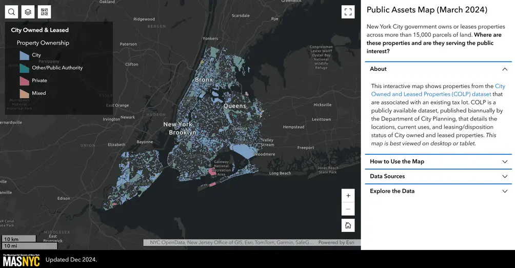 Municipal Art Society of New York's Public Assets Map (March 2024) | https://experience.arcgis.com/experience/55433f4378ea48f3bb900ecb89897fac
Turning Underutilized Land into Housing
If MASNYC’s calculations are correct, and there are roughly 11,000 acres of underused city-owned lots that might be used to build more housing, there is no guarantee these lots will ever become housing. In fact, this is where the LIFT Task Force’s work is bound to get even more challenging.
 Sunnyside Yards: A 166-acre railyard owned primarily by Amtrak, with portions controlled by the Metropolitan Transportation Authority and the city holding air rights over some of the property. The site has long been eyed for a massive deck-over redevelopment for housing and other uses.
New York City is divided into many manufacturing, commercial, and residential zones. Each type of zone has its own sub-zones and each of these has its own set of unique restrictions (read more about the City’s convoluted history of zoning laws here). For this reason, it seems likely that many of the underused lots the LIFT Task Force discovers will not be zoned residential. Undoing existing zoning designations, however, is no easy task. In New York City, it usually takes years, not months. But even lots that are already in a residential zone may or may not be easily appropriated for future housing.
Currently, there are 10 residential zoning districts in NYC, each with its own constraints. For example, if the LIFT Task Force discovers an unused or underused city-owned lot, and it happens to be in an R6 zoning district (these are built-up, medium-density areas in Brooklyn, Queens, and the Bronx), it may or may not be possible for the City to move forward with building residential housing on the lot in question. First, the lot size determines how tall the building can be, which can limit the number of units that can be built. There is also generally an expectation that off-street parking be available for at least half of the building’s dwellings, though this can be lower if the intent is to build income-restricted units.
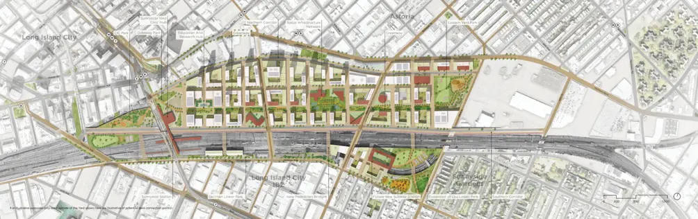 Site plan of Sunnyside Railyards redevelopment concept designed by PAU | https://pau.studio/what/sunnyside-yard/
The LIFT TASK FORCE’s July 1 Deadline
Despite the daunting task ahead, the LIFT Task Force has a clear mandate: “No later than July 1, 2026,” they must identify “sites owned and controlled by the City or such agencies, offices or entities that are appropriate to support at least 25,000 new housing units over the next ten years.” Whether or not the task force delivers—and their work leads to more housing over the coming decade—is yet to be seen. This also isn’t the first time in recent history that a mayor has attempted to turn vacant and underused City properties into housing.
 Former mayor Eric Adams and a conceptual rendering of the Gansevoort Square project planned on city-owned land in the Meatpacking District
In 2024, Mayor Adams signed Executive Order 43, which required all City agencies to “Review all land under the ownership and control of the City or of other participating and cooperating agencies and entities, and enlist the collaboration of City agencies and such other agencies and entities, to identify potential sites for housing development.” While some lots were identified in the process, to date, few New Yorkers can likely point to the visible impact Executive Order 43 has had on the City’s ongoing housing shortage. Only time will tell if Mayor Mamdani’s Executive Order 04 can not only identify additional vacant and underused lots but fast-track their rezoning to pave the way for an influx of new residential developments citywide.
 Unselected proposal for Gansevoort Square by Powerhouse Company and SO IL known as 5050 Gansevoort (Credit: Powerhouse Company | SO IL)
 100 Gold Street is planned to be redeveloped into a mixed-income residential development with about 3,700 units, at least 25% permanently affordable, as part of Eric Adams’ 2025 Manhattan Plan to create 100,000 new homes in the borough. GFP Real Estate was selected to redevelop the city-owned site in December 2025.
Would you like to tour any of these properties?
Related Articles

Future New York
What's old is new again: Mass timber construction in NYC as Timberburg readies to launch sales
Today, June 16, 2026
Future New York
NYC Contracts: $80M trophy penthouse signed at 80 Clarkson; One High Line's last penthouse finds a buyer
Today, June 16, 2026
Future New York
Manhattan sales include Emmy-winning producer's CPW co-op; Closings begin at The Willow
Today, June 16, 2026
Get To Know
What New York’s transparency bill could mean for whisper listings + Public listings with open houses
Friday, June 12, 2026
Get To Know
What the pied-à-terre tax could mean for Manhattan prices + NYC penthouse listings from $499K
Friday, June 12, 2026
Future New York
Price Cuts: Former Kips Bay Decorator Showhouse down by $9.5M; Karim Rashid to take loss on Hell's Kitchen condo
Thursday, June 11, 2026
Future New York
Top 10 condos in Turtle Bay and Beekman-Sutton Place + New developments and price-reduced listings
Thursday, June 11, 2026
Future New York
Over $600M in Manhattan contracts include FiDi penthouse with indoor slide and Mish Fine Jewelry founder’s Village co-op
Wednesday, June 10, 2026
Contributing Writer
Cait Etherington
Cait Etherington has over twenty years of experience working as a journalist and communications consultant. Her articles and reviews have been published in newspapers and magazines across the United States and internationally. An experienced financial writer, Cait is committed to exposing the human side of stories about contemporary business, banking and workplace relations. She also enjoys writing about trends, lifestyles and real estate in New York City where she lives with her family in a cozy apartment on the twentieth floor of a Manhattan high rise.