 601 West 29th Street and 606 West 30th Street (Credit: FXCollaborative and ILA)
It’s easy to forget that Manhattan was once a natural place. You could almost assume that when Henry Hudson sailed passed the island on that September afternoon he too saw jutting piers and a grid-iron of streets crisscrossing a topographically flat island. Of course, this is far from the truth, and when digging through bits of historic documents we remember how much the island has changed in a relatively short period of time. Focusing on a fairly atypical Manhattan block, “Block 675”, at Eleventh Avenue between 29th and 30th street, one could track a series of transformations that were common near the city's waterways.
Enlarge Image
Enlarge Image
Enlarge Image
Enlarge Image
Enlarge Image
Enlarge Image
Enlarge Image
Enlarge Image
Enlarge Image
Enlarge Image
In this article:
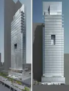
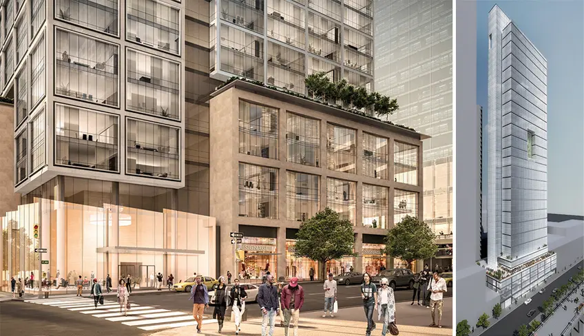
Situated at the doorstep of Hudson Yards, Lalezarian Properties and Douglaston Development are separately erecting a pair of mixed-use skyscrapers on infill land that was once far out in the Hudson River some 200 years ago. Douglaston Development, a pioneer in the area when they finished the rental tower 'Ohm' in 2010, is behind the larger of the two towers at 601 West 29th Street.
Portions of the tower's six-story podiums has already begun to rise. The tower spans a full blockfront of Eleventh Avenue and replaces a gas station and former studio of artist Jeff Koons. FXCollaborative (formerly FXFowle Architects) are the designers of the tower and images show an L-shaped, 58-floor building that would rise 637 feet tall to its rooftop bulkhead. Planned inside are 938 apartments, 186 parking spaces, and ground-level retail.
Portions of the tower's six-story podiums has already begun to rise. The tower spans a full blockfront of Eleventh Avenue and replaces a gas station and former studio of artist Jeff Koons. FXCollaborative (formerly FXFowle Architects) are the designers of the tower and images show an L-shaped, 58-floor building that would rise 637 feet tall to its rooftop bulkhead. Planned inside are 938 apartments, 186 parking spaces, and ground-level retail.
Enlarge Image
Enlarge Image
Enlarge Image
Enlarge Image
Enlarge Image
Enlarge Image
Enlarge Image
Enlarge Image
Within the “L” of the Douglaston building would be Lalezarian’s project at 606 West 30th Street (Project Site B). The 37-floor building would be designed by Ismael Leyva Architects and have an estimated 219 apartments, 47 parking spaces and 22,458 square feet of commercial space inside.
Enlarge Image
Enlarge Image
Enlarge Image
Enlarge Image
Enlarge Image
Enlarge Image
The massing of the two towers is to be responsive to the High Line and serve as a transitional area between the supertalls of Hudson Yards and the loft buildings of West Chelsea. Retail is to be provided on the ground floor across from the High Line and there would be a terrace above matching the height of the elevated park. Both buildings will abide by the recently-instituted Mandatory Inclusionary Housing (MIH) where up to 30% of all units will be earmarked for low and/or moderate-income households. If the project is approved, construction is set to begin by year-end.
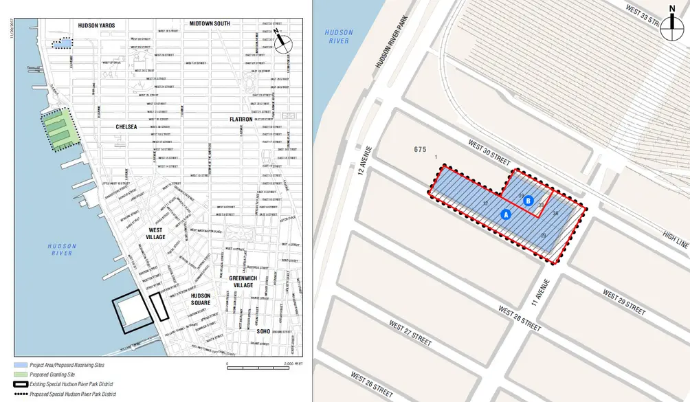 Current maps showing Block 675 and transfer area via DEIS
To move forward with the developments, the developers jointly requested the transfer of unused development rights from Chelsea Piers, via the Special Hudson River Park District. They also successfully rezoned the site to permit residential uses. A draft environmental impact study, seemingly longer than the Talmud, was submitted to City Planning department in November 2017 and approved the following year with some modifications such as lopping off several stories of the taller tower at 606 West 29th Street to provide a smoother transition in scale bewteen Hudson Yards and West Chelsea.
The EIS documents determined all the possible impacts the transfer and rezoning would have on the surrounding area — looking at aspects ranging from traffic to sanitation to how the towers will affect the High Line’s plants. In one of the appendices, a fascinating compilation of historical maps illustrates how much the general area has evolved, and that prior to man-made interventions, the site was roughly 800’ offshore in the Hudson River.
The EIS documents determined all the possible impacts the transfer and rezoning would have on the surrounding area — looking at aspects ranging from traffic to sanitation to how the towers will affect the High Line’s plants. In one of the appendices, a fascinating compilation of historical maps illustrates how much the general area has evolved, and that prior to man-made interventions, the site was roughly 800’ offshore in the Hudson River.
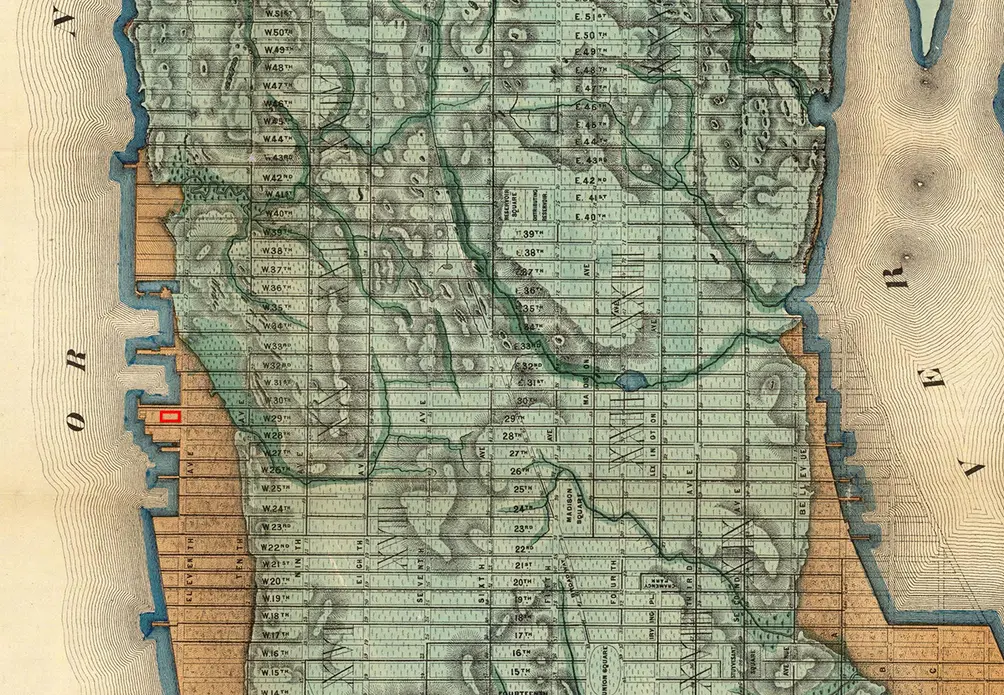 Viele Map of 1865. Project site shown in red to the left
In the Viele Map (above), which depicts Manhattan’s original shoreline and natural features overlaid with the 1811 street grid and the waterfront 1865, shows the site was near the mouth of a small stream that began near where Penn Station is now and ended by Tenth Avenue at Chelsea Park.
As the city steadily expanded northward and cemented itself as the entrepot connecting the Great Lakes, the Caribbean, and Europe; maps from the mid-1800s show how the shoreline crept westward through landfilling. While the Chelsea-Far West Side waterfront remained industrial with lumber yards, smelting and refining facilities, and iron works; new residential districts such as the London Terrace rowhouses (demolished), began infilling once vacant blocks further inland.
A closer look at the project area shows that for much of the last century the immediate area has maintained its light-industrial uses geared towards vehicle repair and freight business. The recently-closed gas station at the project site has been operating as one since 1927 and the sanitation facility next door has been used for equipment storage/maintenance since the 1970s.
After being filled in from below, the area is now taking to the skies. Related Companies/Oxford’s Hudson Yards project between West 30th and 34th streets and from Tenth Avenue to the river is the largest private real estate development in U.S. history.
Additionally, the conversion of the former freight line, the High Line, and a Bloomberg rezoning has brought a tidal wave of new development to the area. Across Eleventh Avenue from the Douglaston, Tamarkin has wrapped up construction on on SoHy at 550 West 29th Street which currently has a 3-bedroom for rent at $15,000/month.